By Glynn Wilson –
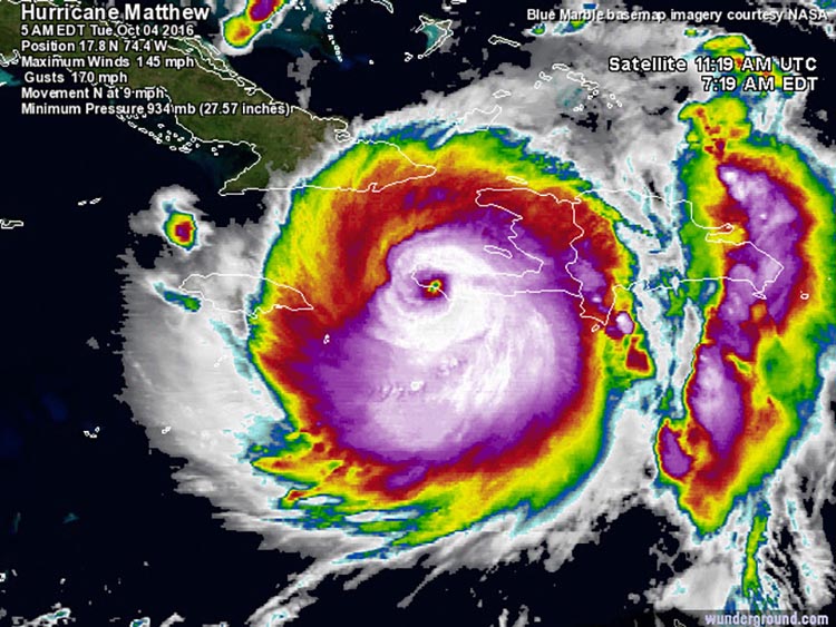
Powerful Hurricane Matthew made landfall on the southwestern tip of Haiti near 7 a.m. October 4 as a Category 4 storm with 145 mph winds, and was on track to hit Florida and head for North Carlonia on Tuesday.
The hurricane is the third strongest one ever recorded in the impoverished nation, and their strongest hurricane in 52 years. The only Haitianfind hurricanes stronger than Matthew were two Category 4 storms with 150 mph winds: Hurricane Cleo of 1964 and Hurricane Flora of 1963. The last major hurricane to make a direct hit in Haiti was Category 3 Hurricane David of 1979, which crossed over the nation from east to west with 115 mph winds.

Infrared satellite image of Hurricane Matthew as it made landfall over the southwestern tip of Haiti at 7:19 a.m. EDT October 4, 2016.
“We don’t have many weather stations in Haiti, so it is difficult to say what the conditions are on the ground,” a meterologist with the National Wether Service said on the Google Wunderground weather site.
A personal weather station on the south coast Haiti at Aquin, about 70 miles east of Matthew’s landfall, recorded a wind gust of 59 mph at 6:50 a.m. EDT Tuesday. A PWS near Port-Au-Prince, Haiti recorded about 1.70” of rain during the 36-hour period ending at 7 a.m. EDT Tuesday. At the Port-Au-Prince airport, top winds on Tuesday as of 8 a.m. EDT were 34 mph, gusting to 52 mph.
An Air Force hurricane hunter aircraft arrived at Matthew’s center near 8 a.m. EDT Tuesday, when the eye was over land. The plane did not fly directly into the center of the eye, since that would have risked penetrating through extreme turbulence over land, but the aircraft was able to measure a central pressure of 944 mb at the edge of the eye. The peak winds measured by their SFMR instrument were 135 mph, so Matthew was definitely a solid Category 4 storm at landfall.
Satellite loops on Tuesday morning showed that the encounter with land had weakened the storm, with the eye much less distinct. Light wind shear of 5 – 10 knots is affecting the storm, and Matthew is over warm ocean waters of 29°C (84°F) and has plenty of moisture to work with – 70-75% relative humidity at mid-levels of the atmosphere.

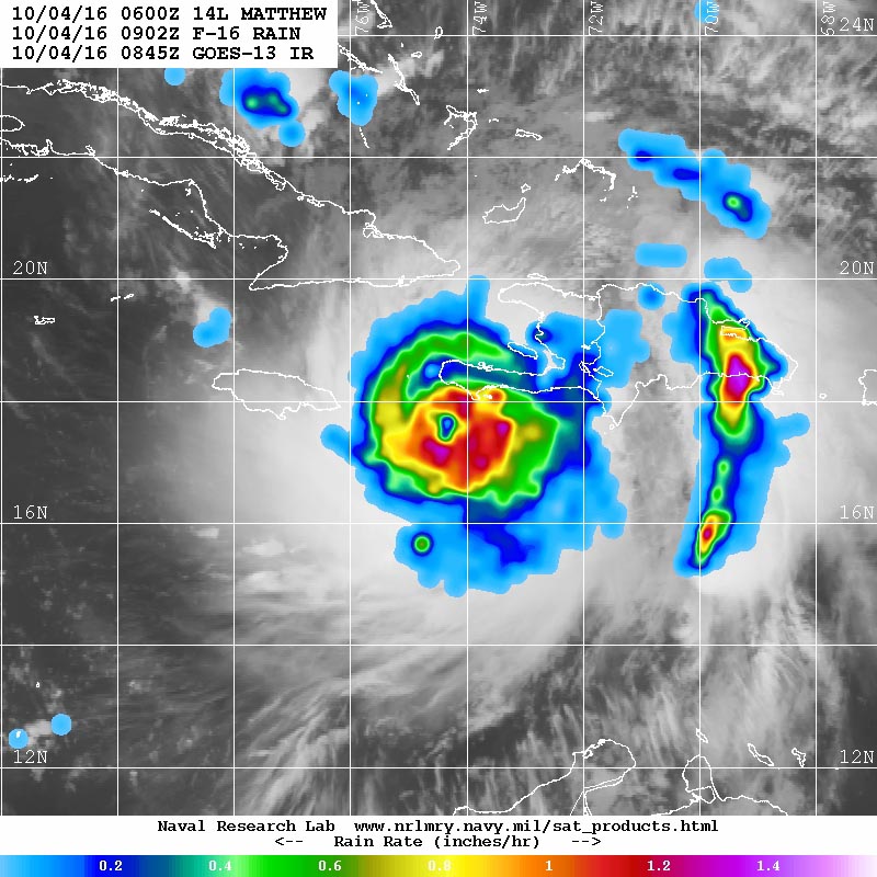
Microwave image of rainfall rates in Hurricane Matthew from the F-16 polar orbiting satellite taken at 5:02 a.m. EDT October 4, 2016. At the time, Matthew was a Category 4 storm with 145 mph winds. Rainfall amounts in excess of 1”/hour (orange colors) were occurring along the coasts of Haiti and the Dominican Republic: NRL Tropical Cyclone Page.
Extreme rains from Matthew are a huge concern for the entire island of Hispaniola, thanks to an unusual area of extra spin and low pressure that has been embedded on the east side of Matthew’s circulation for days. This feature began rotating ashore over southern Haiti and the Dominican Republic early Monday morning, and continues to affect the Dominican Republic this morning.
The mountainous terrain of the island has caused tremendous uplift to the thunderstorms moving ashore, resulting in extremely intense rainfall. A personal weather station (PWS) in Cabo Rojo, on the southern coast of the Dominican Republic near the border with Haiti, recorded 22.89” of rain on Monday, including a remarkable 5.33″ in the hour from 6 a.m. to 7 a.m.. An additional 3.73” fell on Tuesday as of 8 a.m. EDT, for a storm total of 26.62”. While PWS data is often suspect, these are believable rainfall amounts based on the satellite presentation of Matthew.
Intensity Forecast for Matthew
Landfall in Haiti on Tuesday morning and on eastern Cuba on Tuesday evening will disrupt the hurricane, and could cause it to weaken by one Saffir-Simpson category, to a Category 3 storm.
“However, Matthew is a very large and well-organized storm, and it may take it only a day to recover from its disruption,” said Jeff Masters with the National Weather Service.
The latest SHIPS model forecast predicts that wind shear will remain light to moderate, 5 – 15 knots, through Friday. Ocean temperatures will be very warm, between 29 – 30° C (84 – 86°F) and the heat content of the ocean will be high to very high, which argues for intensification of Matthew.
“Our top three intensity models were predicting on Tuesday morning that Matthew would be at Category 3 or 4 strength through Friday,” Masters said.
Track Forecast for Matthew
“The significant westward shift in computer model guidance on Hurricane Matthew that occurred yesterday is holding, and we now have increased confidence that Matthew will bring severe impacts to the Southeast U.S. coast from South Florida to Cape Hatteras, North Carolina,” the Weather Service is saying.
Matthew will continue northwards after clearing the southwest tip of Haiti Tuesday morning, then make a second landfall in eastern Cuba at about 6 pm EDT Tuesday. Matthew will turn north-northwest and then northwest on Wednesday, and traverse The Bahamas from southeast to northwest Wednesday morning through Thursday morning. In their 5 a.m. EDT Tuesday Wind Probability Forecast, NHC gave highest odds of hurricane-force winds in The Bahamas to Great Exuma (57%), New Providence (46%), and Grand Bahama (37%).
“Late Thursday morning, Matthew will be very close to the coast of South Florida, and is expected to turn more to the north-northwest, almost parallel to the coast, at that time,” the Weather Service says.
Models did not show a Florida landfall, but brought the hurricane so close to Florida — within 50 miles — that most of the coast of Florida from West Palm Beach to Daytona Beach would experience sustained winds of at least 50 mph.
Matthew is expected to turn more to the north and then north-northeast on Friday, which will keep the storm very close to the coasts of Georgia, South Carolina, and North Carolina.
“At this time, our top models suggest that the greatest probability for a U.S. landfall by Matthew is in South Carolina on Friday night or North Carolina on Saturday morning,” the Weather Service is saying.
After its closest approach to the coast of North Carolina, they have a number of reliable models predicting that Matthew will continue north-northeast and hit New England on Sunday, with eastern Massachusetts being at greatest risk. Landfall in New England would very likely not be at hurricane strength, due to the potential for Matthew to pass over a lot of land before getting there.
“The risk to New England is not clear at this point, though, since we have some model guidance predicting a more northeasterly path for Matthew, keeping the center of the storm several hundred miles east off the Northeast U.S. coast,” the NWS says.


