Staff Report –
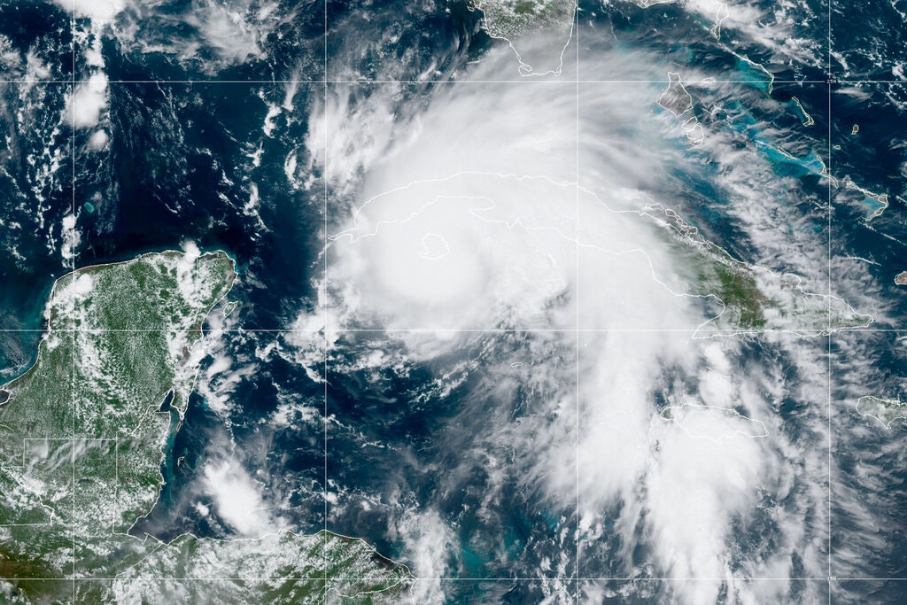
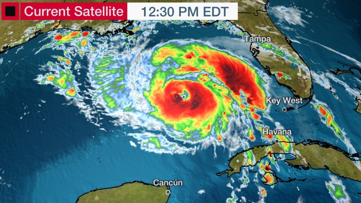
Hurricane Ida is forecast to rapidly intensify into a major hurricane as it draws closer to the northern Gulf Coast this weekend, where it will bring life-threatening storm surge, dangerous rainfall and flooding, and potentially catastrophic winds and tornadoes on the 16th anniversary of Hurricane Katrina.
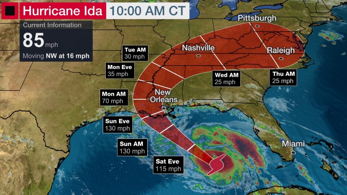
Ida is currently centered 400 miles southeast of New Orleans and is tracking northwest at just over 16 mph, according to the National Weather Service. Maximum sustained winds are 85 mph, making Ida a Category 1 hurricane.
People along the northern Gulf Coast from Louisiana to Alabama should monitor Ida’s progress closely and finish hurricane preparations on Saturday. Follow the advice of local officials if you are ordered to evacuate.
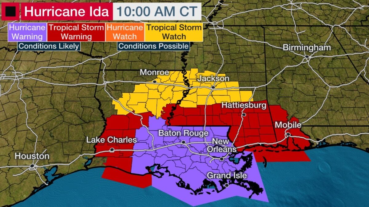
A hurricane warning is posted from Intracoastal City, Louisiana, eastward to the mouth of the Pearl River, including Lake Pontchartrain, Lake Maurepas, and the New Orleans metro area. Tropical-storm-force winds are forecast to arrive in parts of this region late Saturday night into early Sunday, with hurricane conditions developing Sunday and Sunday night.
A tropical storm warning is posted from Cameron, Louisiana east to Intracoastal City, Louisiana, and from the Pearl River in Louisiana to the Alabama/Florida border. Tropical storm warnings are also in effect for inland southern Mississippi. Tropical storm conditions are expected to begin Saturday night or early Sunday morning.
A tropical storm watch has been issued for inland portions of Mississippi and Louisiana, where tropical storm conditions are possible within 48 hours.
Storm Surge
A storm surge warning has been issued from the Rockefeller Wildlife Refuge, Louisiana, to the Mississippi/Alabama border including Vermilion Bay, Lake Borgne, Lake Pontchartrain, and Lake Maurepas, meaning life-threatening inundation from storm surge is expected in these areas within 36 hours.
A storm surge watch is also in effect for Mobile Bay. This means dangerous flooding from storm surge is possible within the next 48 hours.
Forecast Track, Intensity
An area of high pressure over the Southeast U.S. will be the large-scale steering wheel for Ida, with its clockwise circulation sending it northwestward toward a landfall along the Louisiana coast late Sunday into early Monday. Keep in mind that impacts will arrive on Sunday before landfall occurs and that impacts will extend outside the forecast path shaded red in the map below.
Hurricane Ida is expected to intensify in the Gulf of Mexico, likely rapidly, as it moves northwestward due to very warm waters in the Gulf of Mexico along with favorable upper-level winds, so she is currently expected to be at major hurricane strength at landfall, possibly even Category 4 intensity, when it approaches the northern Gulf Coast on Sunday.
Ida could make landfall as a major hurricane on the 16th anniversary of Hurricane Katrina’s landfalls in southeast Louisiana and Mississippi on Aug. 29, 2005.
Four named storms, including three hurricanes (Laura, Delta and Zeta), made landfall in Louisiana in 2020.
Storm Surge
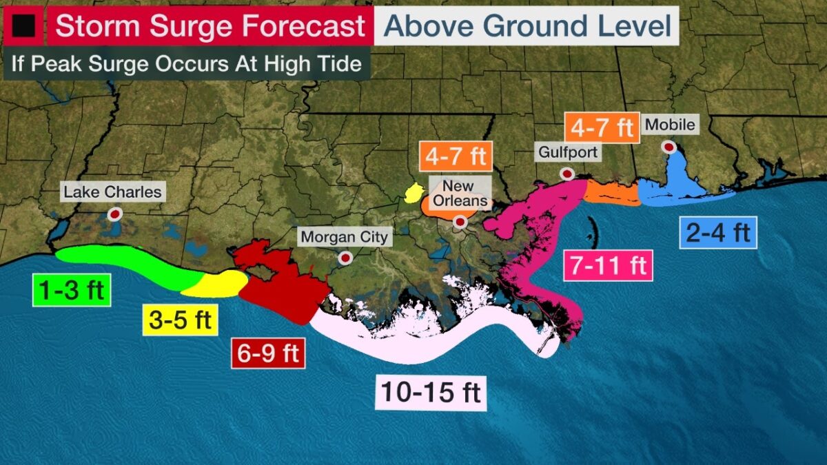
Life-threatening storm surge is forecast near and east of where Ida makes landfall. Offices urge people to follow all evacuation orders from local officials if you are in an area vulnerable to storm surge.
The following storm surge inundations are possible if the peak surge happens at high tide, according to the National Hurricane Center (NHC). High tide is generally in the early morning hours of Sunday and Monday for many locations along the coasts of Louisiana and Mississippi.
-Morgan City, Louisiana, to the mouth of the Mississippi River: 10 to 15 feet
-The mouth of the Mississippi River to Ocean Springs, Mississippi, including Lake Borgne: 7 to 11 feet
-Intracoastal City, Louisiana, to Morgan City, Louisiana, including Vermilion Bay: 6 to 9 feet
-Ocean Springs, Mississippi, to the Mississippi-Alabama border: 4 to 7 feet
-Lake Pontchartrain: 4 to 7 feet
-Lake Maurepas: 3 to 5 feet
-Pecan Island, Louisiana, to Intracoastal City, Louisiana: 3 to 5 feet
-Mississippi/Alabama border to Alabama/Florida border, including Mobile Bay: 2 to 4 feet
-Sabine Pass to Pecan Island, Louisiana: 1 to 3 feet
This peak surge will occur within an hour or two of Ida’s landfall. However, some coastal flooding could also occur in areas of onshore flow as soon as early Sunday morning that may cut off escape routes from the coast.
The NHC also notes that overtopping of local levees outside of the hurricane and storm damage risk reduction system is possible where local inundation values may be higher.
Rainfall Levels
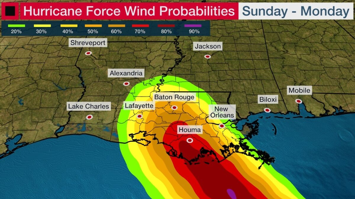
Tropical storm conditions could arrive in the hurricane warning area as soon as late Saturday night, which will make hurricane preparations dangerous. Hurricane conditions should develop during the day Sunday into Sunday night.
The NHC said wind damage could be “potentially catastrophic” near where the core of Ida makes landfall in Louisiana.
Downed trees, widespread power outages and some structural damage are possible in the hurricane warning areas.
At least tropical-storm-force winds are expected to punch into inland parts of Louisiana and Mississippi through Monday.
Rainfall Forecast
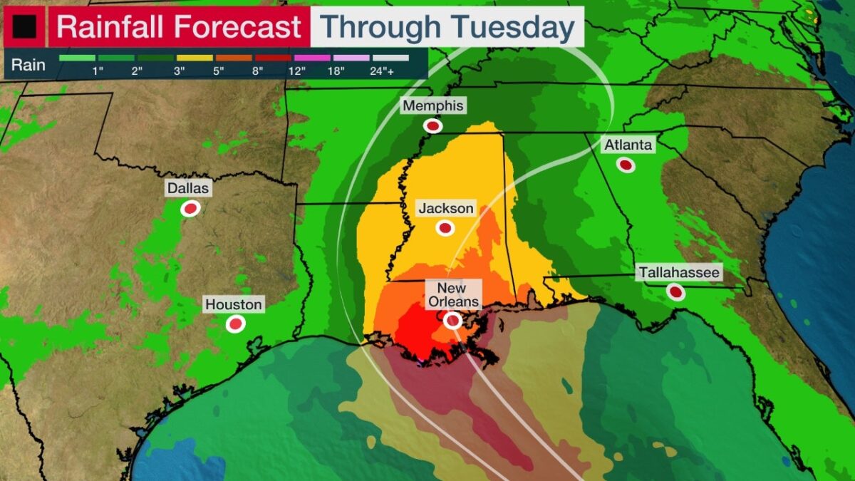
Widespread flash flooding, particularly where bands of rain stall for a period of a few hours, is expected along the path of Ida. Heavy rain will also lead to river flooding that could linger for several days after the storm.
At least a local flash flood threat will also penetrate inland into the Deep South and Tennessee Valley Monday and Tuesday.
NOAA’s Weather Prediction Center is forecasting the following rainfall totals:
-Southeast Louisiana and southern Mississippi: 8 to 16 inches with isolated 20-inch totals through Monday.
-Northeast Louisiana to central Mississippi and the Tennessee Valley: 4 to 8 inches.
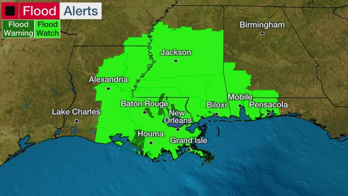
Flood watches have been issued by the National Weather Service for this dangerous heavy rainfall threat from the eastern half of Louisiana into parts of southeast Arkansas, Mississippi, southwest Alabama and the western Florida Panhandle.
High surf and rip currents will affect the northern Gulf Coast beginning Saturday night or early Sunday.
Tornadoes
Isolated tornadoes are frequently a concern with landfalling tropical cyclones.
Some rotating cells in Ida’s rainbands may spawn tornadoes not only near coast as it heads toward land Sunday, but also inland over the South Monday into Tuesday.
As a reminder, Tropical Storm Fred spawned 29 tornadoes from the South to the Northeast over a week ago.
Forecast changes are likely over the next couple of days, so check back with us at weather.com for important forecast updates.
Officials urge people to ensure they have a hurricane plan in place in case this system becomes a growing threat where you are.
Before you continue, I’d like to ask if you could support our independent journalism as we head into one of the most critical news periods of our time in 2024.
The New American Journal is deeply dedicated to uncovering the escalating threats to our democracy and holding those in power accountable. With a turbulent presidential race and the possibility of an even more extreme Trump presidency on the horizon, the need for independent, credible journalism that emphasizes the importance of the upcoming election for our nation and planet has never been greater.
However, a small group of billionaire owners control a significant portion of the information that reaches the public. We are different. We don’t have a billionaire owner or shareholders. Our journalism is created to serve the public interest, not to generate profit. Unlike much of the U.S. media, which often falls into the trap of false equivalence in the name of neutrality, we strive to highlight the lies of powerful individuals and institutions, showing how misinformation and demagoguery can harm democracy.
Our journalists provide context, investigate, and bring to light the critical stories of our time, from election integrity threats to the worsening climate crisis and complex international conflicts. As a news organization with a strong voice, we offer a unique, outsider perspective that is often missing in American media.
Thanks to our unique reader-supported model, you can access the New American journal without encountering a paywall. This is possible because of readers like you. Your support keeps us independent, free from external influences, and accessible to everyone, regardless of their ability to pay for news.
Please help if you can.
American journalists need your help more than ever as forces amass against the free press and democracy itself. We must not let the crypto-fascists and the AI bots take over.
See the latest GoFundMe campaign here or click on this image.
Don't forget to listen to the new song and video.
Just because we are not featured on cable TV news talk shows, or TikTok videos, does not mean we are not getting out there in search engines and social media sites. We consistently get over a million hits a month.
Click to Advertise Here


